
NEW! We’ve got two ways to get your weather now…read Jackson’s forecast or scroll down to the bottom and watch our NEW video forecast!
We’re approaching February, which is typically when we experience our most significant winter storms of the season. That may be verified somewhat, as we have three separate chances for snow within the next seven days (Jan. 29-Feb. 4).

Monday, Jan. 29: Monday will be a beautiful day to begin the new week, featuring mostly sunny skies and high temperatures in the low 40s. Meanwhile offshore, there is a coastal storm that continues to grab our attention. The models have begun to hone in on a similar solution with the storm staying far enough offshore for zero impacts.
Tuesday, Jan. 30: We’ll continue to watch the coastal storm this Tuesday, but snow from another system is also possible. An upper-level low over the Northeast will aid in the development of a light snow, but I’m thinking this snow will be confined to the Mid-Atlantic region. Therefore, I’m forecasting more clouds than sun with only the slight chance for a snow shower.

Wednesday, Jan. 31: High pressure will build in midweek, shutting off the chance for snow completely. Wednesday will be a beautiful day featuring sunny skies and high temperatures right around the freezing mark as we continue to ride the “temperature roller coaster.”
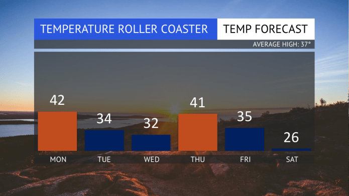
Thursday, Feb. 1: Temperatures will warm back up for our Thursday with a high into the low 40s. Expect intervals of clouds and sunshine ahead of our next approaching storm, which will move in on Friday.
Friday, Feb. 2: There is a very credible chance for snow and perhaps significant snow on or around the Friday time period. A developing storm in the Mid-Mississippi Valley will track through the Mid-Atlantic and then offshore, bringing precipitation from the Mid-South through New England. Where the snow falls and how much will come down is still to be determined because the forecast revolves around where the storm will track. I think there will be enough cold air due to an Arctic high pressure over the Central U.S., but the track of the low will determine where the warmer air intrudes.

Saturday, Feb. 3: That chance for snow may continue into our Saturday, but otherwise that Arctic high pressure will begin to move toward the East Coast. That means sunshine and chilly temperatures are ahead for our first weekend of February.
Sunday, Feb. 4: The high will quickly move offshore on Sunday, allowing for our next storm system to move in, which will bring snow and/or rain. This is very far out in time for the modeling to accurate predict this storm, so stay tuned.


Jackson Dill is a Wilton High School senior who started the website, Jackson’s Weather. His 7-day forecast will appear each Monday on GOOD Morning Wilton. Visit Jackson’s Weather to find out any changes in the forecast. You can also follow him on Facebook, Twitter, and Instagram @JacksonsWeather for around-the-clock updates.

